Tag Archives: SAR

Speed Kills

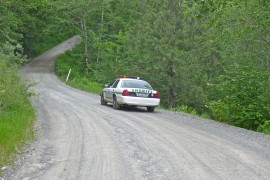
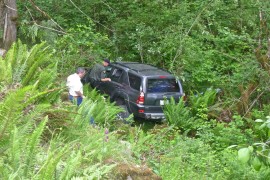
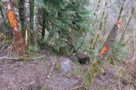
An unnecessary tragedy occurred on February 8, 2014 when a Toyota Land Cruiser going too fast heading up the Middle Fork road veered out of control, shearing off trees and coming to rest on boulders ten feet below the road bed. Car parts were scattered throughout the area indicating a particularly violent collision. 17-year-old Calvin Hancock was sitting in the rear passenger seat and was killed, pronounced dead at the scene. The three others in the car were brought to the hospital to be treated for injuries. The group were on their way to rescue other friends who had vehicle trouble further up the road.

This road in particular is not safe for fast driving, if any are. Calvin’s mother expressed appropriate grief and anger in response to this accident as a comment to a Snoqualmie Valley Record story“The boy who died was our son. I hope all of his classmates learn from this tragic event. Too much speed and lack of driving experience are the sole reason for what happened. Your parents aren’t trying to bother you. Your parents have experience. The next time an officer pulls you over and yells at you for being an idiot, remember that he may have just seen one of these horrible, horrible accidents and another dead teen.” Amen to that.

20140210SpeedKills01

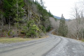
Site of accident at MP 6.4

20140210SpeedKills02

Memorial photo and flowers


Related coverage

    20140210SpeedKills03

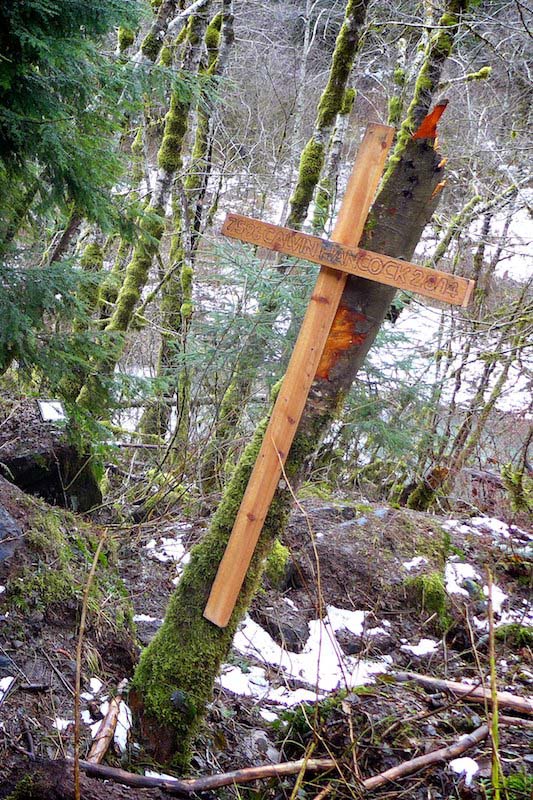
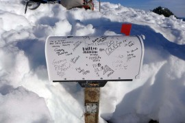
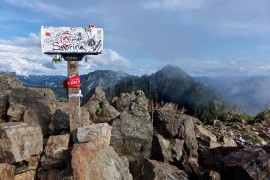
    Calvin Hancock memorial

  • 2014/02/10 Teen killed in weekend crash near North Bend
  • 2014/02/10 Valley teen killed in SUV accident along Middle Fork Road
  • 2014/02/12 Memorial service is Friday for teen killed in Middle Fork accident

Skier injured in fall by Snow Lake

20140125CliffAndBelow

Cliff and slope where skier fell

A backcountry skier in the vicinity of Snow Lake divide was badly injured when he slid hundreds of feet down the north side of the ridge towards the south end of Snow Lake, coming to rest in the trees about 100 feet above the lake. According to his skiing partner JPH at nwhikers.net, “he’s pretty banged up, but in the end it was a broken arm, stitches in the face and lots of big bruises – definitely not as bad as originally anticipated.” A more detailed account is in a post on Turns All Year. Fortunately he was wearing a helmet or this could have turned out much worse. A nearby party of three at Snow Lake saw the accident and came over to help, speeding the call to SAR and avoiding leaving the injured skier alone. King County’s Guardian 2 search and rescue crews hoisted the injured man to safety and transported him to Harborview Medical Center in Seattle. Seattle Mountain Rescue also participated in the rescue.


Hikers, climbers and skiers in the Snoqualmie Pass area reported the development of a hard icy crust at relatively low elevations. On anything except nearly level ground crampons were necessary for safe travel. The Northwest Avalanche Center issued an unusual non-avalanche hazard alert 3 days before this incident. The party was aware of these conditions and had all the necessary gear along. It underscores how unusual these conditions were where what would normally be a minor slip turned into an uncontrolled fall.

January 22, 2014
NWAC
On 13 January a heavy local freezing rain event occurred in the Snoqualmie Pass area above about 4500 feet, covering the surface with about a 2-3 inch ice crust. This crust should break down over time but a fall on a slope on this surface could result in a long and dangerous ride!

20140125LowMountain

A climber on nearby Low Mountain the same day descends crusty ice using crampons and an ice axe


Related coverage

  • 2014/01/18 Snoqualmie Pass area ice crust alert
  • 2014/01/25 Skier injured after fall from cliff at Snow Lake
  • 2014/01/26 Saturday heli-evac from Snow Lake
  • 2014/01/26 Back Country Skier Falls off 400 Foot Ice Cliff Near Snow Lake
  • 2014/01/27 Mountains Prove Treacherous over Weekend: Snoqualmie Woman Dies, Two Men Injured
  • 2014/02/01 SMR – February 2014 newsletter with an account of this incident

Busy rescue year on Mailbox Peak

20130630BusyMailbox01

Summit register page

DayHikingSnoqualmieRegionDespite a steep indistinct trail and 4000 feet of gain, Mailbox Peak has become one of the most popular day hikes in the central Cascades. On Sunday, June 30, 2013 over 100 hikers signed the summit register and many who hike the peak regularly don’t bother with that formality. The Day Hiking Snoqualmie Region guide book leads with “Wimpy hikers, turn the page. This trail offers nothing for you but pain and heartbreak”, and yet thousands each year test themselves.

20130202BusyMailbox02

Mailbox, February 2013

20130630BusyMailbox03

Mailbox, June 2013 by masterqhuy

20131116BusyMailbox05

Mailbox, November 2013

20130903BusyMailbox04

Mailbox, September 2013


Unfortunately some come unprepared, get lost, start too late, or suffer an unfortunate slip and can’t get down before dark or on their own power and that happened a lot in 2013. Stranded hikers enjoy good cell phone coverage on this trail so they generally call 911 and get routed to the King County sheriff’s office who coordinates with Seattle Mountain Rescue to respond. Even if the hikers don’t know exactly where they are, SMR is able to triangulate an approximate location based on cell tower timings. Their records list these missions, and you can bet that lots of others didn’t call them and limped down on their own. Reading these can be useful to help other parties plan better, use caution, and come prepared for a significant effort on a hard trail.

  • April 15, 2013 – At 5:30 pm a hiker injured herself 1 1/2 miles up the trail and was carried down in a litter, reaching the trailhead at 11:30 pm. There was a mix of snow ice and slush on the trail which contributed to the injury and also made it difficult for the rescue team.
     
  • May 3, 2013 – A women injured her ankle while descending and called for help at 5 pm from a spot 2 miles up the trail, then continued walking slowly down. She did not need to be carried and SMR members assisted her down the trail, arriving at 8:30 pm.
     
  • June 30, 2013 – On a hot day an experienced hiker on a training hike was running down the trail following the white diamond trail markers. Then there were no diamonds. He continued down hoping to intersect the trail lower on the mountain, but he was on the south side heading for the Fire Training Center. There are some old trails on that side but they are faint and one could cross them without even noticing. He called for help at 6 pm and the SMR team was able to find him with the help of a GPS signal from his phone. Ironically, heading in the right direction they were able to make it down to the cars in only 11 minutes.
     
  • 20110501BusyMailbox08

    Where’s the trail?

  • October 5, 2013 – Near dusk, a hiker lost the trail called for help at 7:38 pm. Triangulation placed him just below timberline and south of the trail. This is the hardest area to follow the “trail” because it splits into a myriad of paths down a wide area covered in ruts and roots. There are white diamonds but not that close together and it takes some effort to follow them. The hiker was instructed to respond when he heard the searcher’s voices or saw light. They reached him at 10:40 pm and got down just before midnight.
     
  • October 6, 2013 – One day later a similar incident occurred. A lost hiker called near dusk at 7:39 pm and was reached by the rescue team at 9:07 pm. The location isn’t specified, but based on the time to descend it was likely near the same confusing spot as the day before. They were down to the parking at at 11:05 pm.
     
  • October 26, 2013 – Two lost hikers called for help at 8:08 pm, probably after dark. Sadly, they were told by friends to hike Mailbox because it was an “easy beginner’s hike” and that made them think it was ok to start at 1:30 pm. Having lost the trail they ended up making a signal fire at about 1600′, which helped keep them warm and in good spirits. They were reached at 10:30 and got down an hour later.
     
  • November 24, 2013 – A young couple Googled “Mailbox Washington” for their beta, but found it “was harder than it said!”. That’s a stretch because none of the first few results mince words about how difficult this trail is. They had no flashlights, lost the white diamonds, and ten minutes later called for help at 5:30 pm. Via multiple phone calls they were found at 7:13 and down in only 20 minutes. They didn’t realize the white diamonds are only present on the upper parts of the trail, and without a flashlight couldn’t easily follow the trail down.
     

It’s pretty obvious why the DNR, the Sheriff and SMR put up the warning sign at the trailhead, installed the white diamonds, and put in railings at critical points along the trail to keep people on track. Even better will be the new trail currently being constructed by the DNR — look for that to be ready in the fall of 2014.

20120926BusyMailbox07

White diamond

20130903BusyMailbox06

Trailhead warning

Two teens rescued in Pratt

20130702RicardoAndBrian

Ricardo Perez and Brian Chim. Photo: King5 News

On June 30, 2013 two teens, Brian Chim (19) and Ricardo Perez (18), started up the trail to Mason Lake on what was expected to be a hike and a swim on a hot day. Once arriving at the lake they decided to go further, and continued east-bound on the Mt Defiance trail (#1009) toward Rainbow Lake. At the time, much of that trail was covered in snow. In an interview later they said “at some point we just lost the trail in the snow, and then in the creek bed, and then we thought it was a trail but then we continued down the creek bed and we just lost it”. Heading west to get back to Mason Lake, they ended up too far north and were drawn down into the upper reaches of the Pratt Valley near Lake Kulla Kulla, probably on or near the little-used trail below Sir Richard’s Pond (unofficial name).

By 6pm they knew that they were lost when they came across a waterfall instead of the expected lake. The waterfall was probably the outlet of Lake Kulla Kulla. Brian, the more experienced of the two, felt confident that with warm summer weather they could build a fire and it would not be to bad to spend a night out. Ricardo was not so sanguine, saying “Brian kept me together. I was crying like a little girl. … Brian was there and talked me down.” They spent the first night in a “huge ravine” and the next morning had to descend a “phat cliff … we had to go from tree to tree and a couple times we had to traverse over rock faces with 40 foot drops.” During this period on July 1 they saw a helicopter looking for them, so they waited about 6 hours and when the helicopter did not return they headed down to the Pratt River and “took the river as far as we could go.” As the second night came they accepted that it might take longer to be found than expected, and it was difficult staying warm without long pants or a sweater.

On the third day, July 2, they were spotted by a helicopter search team near the confluence of the Pratt and Spider Lake creek. Upon seeing the helicopter again, one of them shook a small tree to get the rescuer’s attention and they were hoisted into the helicopter and taken to Bandera airfield near I-90 exit 45. For spending two nights out they were doing relatively well, being just a little scratched up. Asked what they would do differently next time Ricardo immediately said “NOT HIKE!” To that non-list, Brian added a first aid kit, an emergency blanket, plenty of food, and “make sure the trail I’m going on is an actual trail”.

20130702PossiblePath

Possible path based on published reports

20130629PrattValley01

Pratt River conditions at end of July, 2013

20130629PrattValley02

Snow covered trail beyond Mason Lake where they lost their way

Wing suit jumper missing

On January 3, 2013 Kurt Ruppert, a Florida wing suit enthusiast, jumped out of a chartered helicopter hovering over Mt Si at 6500′ to begin another of his over 1000 thrilling jumps. It was the last time anyone ever saw him. Two companions jumped just before him and were waiting in the landing zone, but did not see him jump, or see his chute deploy. The Mount Si trailheads were closed to function as a base for Search and Rescue operations. About 145 searchers covered a 9 square mile area on the flanks and cliffs of Mount Si for 4 days before concluding that it was unlikely Kurt had survived, given the cold conditions and lack of contact from him. The story drew national coverage because of the sensational nature of the sport and the suspense over whether Kurt had survived. Messages of grief and condolence convey the tragedy of this accident.
Kurt Rupport Jr

Kurt Ruppert Jr


SMR Mt Si search

Mt Si search below west side cliffs – photo by SMR

SMR Mt Si search

Mt Si search – photo by SMR

SMR Mt Si search

Mt Si search, behind the haystack – photo by SMR


Related coverage

  • 2013/01/04 Searchers comb Mount Si for missing skydiver
  • 2013/01/04 Missing Skydiver Identified
  • 2013/01/04 Missing skydiver had made more than 1,000 jumps
  • 2013/01/05 Crews Continue To Look For Skydiver In Washington
  • 2013/01/04 Search for missing Lake City skydiver resumes Saturday
  • 2013/01/05 Crews narrow search area for skydiver in Wash
  • 2013/01/06 Search Suspended: Skydiver Kurt Ruppert Still Missing on Mt. Si
  • 2013/01/06 Ground search ends for skydiver missing in Washington
  • 2013/01/07 Rescuers scour Washington’s Cascade Mountains for missing skydiver
  • 2013/01/07 Police: Missing skydiver likely hasn’t survived
  • 2013/01/09 Search ends for skydiver
  • SMR February newsletter includes details of the search operation.
    Lower three photos courtesy of Seattle Mountain Rescue.

Toyota Misses The Turn

Driving too fast on the Middle Fork road can quickly turn a great day in the mountains into a nightmare. This particular accident didn’t need to happen. The vehicle didn’t make the turn at the most dangerous spot on the road at MP 6.7, skidded off the side and turned at least once before coming to rest right side up in the gully. This incident did not make the news so my assumption is that no-one was seriously hurt or killed. Keep your speed down!

20120615ToyotaMissesTurn01

It’s not a good sign when a police car is stopped at this turn

20120615ToyotaMissesTurn02

This Toyota rolled at least once after it left the road


20120615ToyotaMissesTurn03

This off camber turn combined with loose gravel is treacherous at speed

20120615ToyotaMissesTurn04

Eight months later car parts still litter the gully