Tag Archives: new trail

Mailbox summit trail spares trees

The DNR has been building the new Mailbox Peak trail for several years and it’s nearly complete. Work on the lower switchbacks began in 2012 using a small excavator while another crew worked by hand down from the top. A new parking lot was built in 2013 and by the end of that year the new trail connected with the old trail at 3900′, just below the big talus field. Work continued in succeeding seasons to add bridges, improve drainage at smaller creek crossings, and improve the tread.

In 2016 most of the work was focused on the section of trail through the talus field and continuing on an open ridge to the summit. The old trail alignment veered to the north side of the ridge line and passed through a grove of old growth hemlock trees. They were beautiful and stately, but the impact of thousands of boots stepping on the trail that was in large part roots of these trees threatened their health. Heavy duty rock work was required to construct trail switchbacks through the talus, but this trail will melt out sooner in the spring and is indestructible. Above the talus the tread is now restricted to a single path instead of multiple braids, and much of it has been improved with sturdy rock steps. Previously this was an erosion-prone dirty gully with rocks continually working loose from boot traffic.

Only a short section remains before the new Mailbox trail is completed, and we can expect that to occur in 2017.

20161025NewMailboxTrailThroughTalus

Illustration of work done on this year on the upper section of the new Mailbox trail. The work on the final section to the summit is not complete yet.

20161025Mailbox01

Junction of the new and old trails. The new trail now goes straight ahead instead of steeply up to the left.

20161025Mailbox02

Easy section just past the new/old trail junction

20161025Mailbox03

New switchback on the south side below the talus field

20161025Mailbox04

The new trail enters the talus field on the south side of the ridge. This avoids the rooty trail through the old growth hemlocks which would have harmed them over time.

20161025Mailbox05

New trail through talus

20161025Mailbox11

Building a trail through the talus field. Photo courtesy of DNR.

20161025Mailbox06

The crew did a great job laying flat stepping stones here

20161025Mailbox07

This is the top of talus trail section where the trail leaves the talus field

20161025Mailbox08

The blocked old trail from the other side of the blockage. There’s no reason for anyone to go this way now — the talus field has big views and secure footing.

20161025Mailbox09

Well done rock step work where it used to be semi-loose rocks in a dirty gully

20161025Mailbox10

Obviously this is beyond the point that the trail crew got to. This is what much of the ridge trail used to look like.

DNR hosts Teneriffe trailhead forum

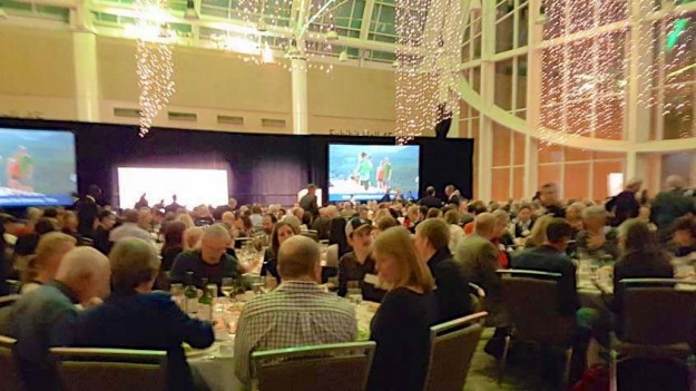
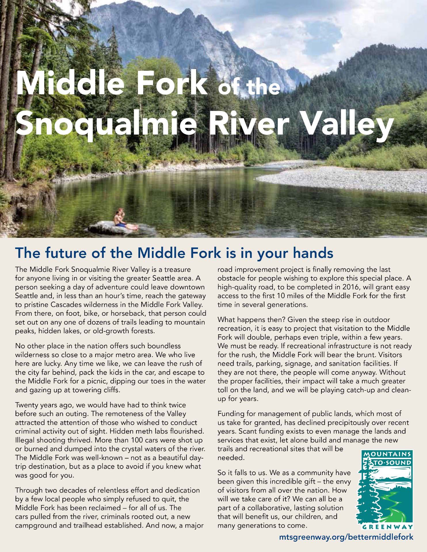
On January 26, 2016 the local DNR staff hosted a neighborhood forum to discuss early stage plans for a new trailhead at the base of Mount Teneriffe. The DNR had previously met with selected neighbors and scheduled a previous forum that was lightly attended because a strong windstorm hit the area that day. This event drew about 40 people, the higher attendance probably due to an article about the meeting in a local newspaper.

20160126TeneriffeTrailheadPlans01

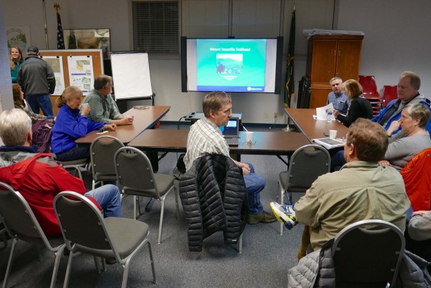
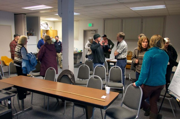
Neighbors filter in as the DNR staff prepares to start the meeting

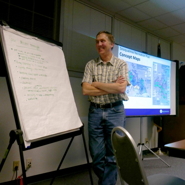
After a brief overview, Doug McClelland of the local DNR office fielded questions and concerns from the audience for over an hour and half. Doug emphasized that the DNR is not trying to draw more recreation related traffic up the narrow SE Mount Si Road, rather it is trying to solve a problem of inadequate parking at the school bus turn-around as the Mount Teneriffe trails become more popular. This Mount Si NRCA project is only one part of a comprehensive Snoqualmie Corridor Recreation Plan including DNR lands on Tiger Mountain, the Raging River valley, Rattlesnake Mountain, and the Middle Fork Snoqualmie NRCA. Most of the trailheads being developed are close to I-90 and do not involve hikers walking or driving through a residential area. That makes this trailhead particularly sensitive and neighbors from the affected area were not shy to voice their concerns.

Issues

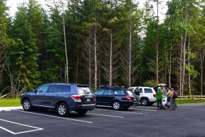
  • Parking and traffic on SE Mt Si Road and in nearby neighborhoods. A few spots along the road are legal to park on, but parking in areas where it’s prohibited only incurs a $20 ticket which most felt is not enough of a deterrent.
  • Safety concerns due to hikers walking along the road when the Mt Si parking lot is full. There are no sidewalks and the shoulder is narrow so the hikers often walk in the traffic lanes
  • Increased traffic on a service level 4 road that receives only minimal maintenance. Most of these issues must ultimately be addressed by King County, but integrated planning by all parties and a coordinated request will probably yield the best results.
  • Concerns about visitors trespassing on private property and inappropriate behavior. One resident found visitors having a picnic on her lawn. Some hikers feel free to change clothes in the middle of the street. Ungated parking lots invite activities unrelated to hiking, including some users frequently staying overnight.
  • Concerns about levels of police patrols and enforcement. This is another issue that extends well beyond the DNR, but should be addressed as part of the plan.

20160126TeneriffeTrailheadPlans04

Doug McClelland fields neighbors questions and concerns


Mitigations

These problems are not going to be easy to solve, but Doug emphasized that there is good cooperation between the various levels of government and other groups funding the projects. Visitation levels have been increasing for years and doing nothing is not a solution. Some of the possible mitigations discussed were

  • Installing a vending machine for purchase a Discover Pass to reduce pressure to park outside the designated areas
  • Continuing the experiment with a shuttle service started in the summer of 2015. It got a lot of publicity but very little use. Ultimately a shuttle service will be needed for both the Mount Si and Middle Fork areas because there will not be enough parking for the anticipated demand. The Middle Fork paving project actually reduces the number of possible parking places because the road is being raised to improve drainage and this results in steep shoulders.
  • Avoid building new trails beyond those that currently exist in the Mount Si NRCA and encourage use of trails in other nearby areas with better access.
  • Consider electronic surveillance to help safety and law enforcement. Automatically monitoring how full the lots are and making the information available online could direct hikers to less busy areas.
  • Improve signage for parking, pass requirements and purchase, and other nearby hiking options

20160126TeneriffeTrailheadPlans05

Attendees got a chance to visit with the local DNR staff after the meeting


Concept Plans

Work on the Teneriffe trailhead and other Snoqualmie Corridor facilities is being funded by a $100,000 grant – RCO 14-1841 Snoqualmie Corridor Facilities Design. The initial thinking when applying for the grant was to build a new parking lot uphill from the school bus turn around where hikers currently park.

2014TeneriffeTrailheadConcept

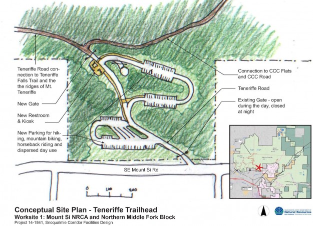
An early trailhead concept from the grant application showed a multi-loop parking lot uphill from the school bus turn around, near the water tower.

Work done as part of the grant evaluated the possible trailhead locations more carefully and the preferred site shifted to area B shown below. The DNR staff stressed that these are still concept drawings. Actual plans require significantly more study to evaluate wildlife, drainage, traffic and other impacts.
20160126TeneriffeTrailheadPlans03

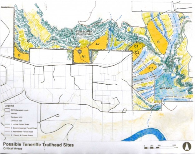
Locations evaluated for a new trailhead. Relatively flat ground and distance from streams and wetlands are advantageous which made the C and D sites unworkable.

20160126TeneriffeTrailheadPlans02

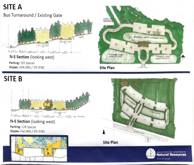
A comparison of the two most likely sites. Site A was initially favored but turned out to have steeper slopes and more difficult drainage problems than site B, the current front runner.

Related news

01/11/2016 Living Snoqualmie – New Hiking Trailhead, 70 Car Parking Lot Planned for Mt. Si Road, Residents Voice Concerns

Work begins on Granite Creek shortcut trail

Work has begun on the new Granite Creek shortcut trail. This trail will start at a new parking lot the DNR plans to build near the concrete bridge and will wind up the ridge west of Granite Creek to join the old road, recently converted to a trail. The new trail starts out on an old logging road but leaves about 1/3 miles in on a new track that stays along the ridge line. For a number of years there has been a little know user-built trail that some hikers have used to shorten the distance to Granite Lakes by about 1 1/2 miles each way. Sections of that trail have always been steep and muddy and the new trail looks like it will be a big improvement when completed. But as of December 26 with recent rains and snow, the new trail is also very muddy and slippery and does not yet connect with the main trail above.

New Granite Creek shortcut trail route. The trail is still being roughed in. The dotted line is based on pink flagging indicating where the rest of the trail will probably be located.

In a 2009 planning document the DNR said “The new trail will follow the old logging road for half a mile, but then leave the road and wind its way up to the east amongst the various stream drainages west of the Granite Creek Canyon. Once above these deeply cut drainages, the trail will climb the dry ground available west of Granite Creek to meet the Granite Road-Trail, utilizing as few climbing turns and switchbacks as possible.”
2009PlanningMap

2009 trail route concept. Planning has been going on for a long time. The route as constructed deviates quite a bit from this early version.

The new trail currently leaves the old logging road about .3 miles from the main road

The new trail currently leaves the old logging road about .3 miles from the main road

The new trail is roughed in with freshly cut banks for now

The new trail is roughed in with freshly cut banks for now

Amenities are already being built such as this bench at a spot with a view over Granite Creek

Amenities are already being built such as this bench at a spot with a view over Granite Creek

The new trail winds back and forth on a ridge and stays much closer to Granite Creek than the old user-built shortcut trail

The new trail winds back and forth on a ridge and stays much closer to Granite Creek than the old user-built shortcut trail

Excavator that's handling the initial trail rough-in

Excavator that’s handling the initial trail rough-in

MTSG dinner features Middle Fork appeal

The Mountain To Sound Greenway held it’s annual celebration dinner on December 2, 2015 at the Washington State Convention Center. As always they presented a series of accomplishments over the year, with the acquisition of land around Valley Camp being of interest here.

20151202ConventionCenter

Mountain To Sound Greenway Dinner & Celebration. Photo by MTSG via Twitter


Besides that acknowledgement, each seat had a flyer on it with an appeal for contributions to support needed infrastruction in the Middle Fork valley. Pages from that flyer are reproduced here and it’s available as a PDF file from the MTSG website. If this is a cause you support, please consider donating to the MTSG which does an enormous amount of good work there.
2015MiddleFork101Handout1

Middle Fork 101 – Page 1

2015MiddleFork101Handout2

Middle Fork 101 – Page 2

2015MiddleFork101Handout3

Middle Fork 101 – Page 3


Of course, it was gratifying to see the use of two photos from this website’s author.
20140802MiddleForkSunbathers

Sunbathers on rock with Garfield Mountain in the background

20150113BigCCCStump

Possibly a stump from what may have been Washington’s biggest tree. 42.5′ circumference, 13.5′ diameter

REI funds Middle Fork trail maintenance

Voters earned $58,790 for the Middle Fork Trail

REI web page with final Middle Fork Snoqualmie River Trail totals

As part of it’s “Every Trail Connects” campaign, REI invited its members and the outdoor community across the country to have a direct effect on the trails they love. Community votes determined how to invest $500,000 with 10 nonprofit partners to support 10 selected trails including the Middle Fork Trail on the Snoqualmie River. Each vote (one per day, per person) meant a $5 investment in the selected trail. The investment is part of $5.9 million that REI is granting in 2015 to more than 300 nonprofits working to create access to more than 1,000 outdoor places throughout the United States.

Because of the 3 hour time zone difference with the east coast, the Middle Fork Trail got off to a slow start, but as word spread on local hiking sites and social media the votes started coming in at a brisk pace. Ultimately, the Middle Fork trail got the 5th highest vote total, just 3,242 votes shy of the maximum 15,000. After the voting was done REI added a $10,000 bonus to each of the 10 trails, raising the total to $68,790.

Progress of voting during REI Every Trail campaign

Progress of voting during REI Every Trail campaign

The funds will help repair multiple washouts on the Middle Fork Trail from the severe November 2006 and January 2009 floods and reroute a section located on a rapidly migrating river bend to higher ground. The project also includes removing approximately 0.5 miles of washed-out trail segments to promote natural re-vegetation and repairing portions of the damaged wood boardwalks. Unfortunately, it’s not enough money to add a badly needed bridge at the Thunder Creek crossing. The work will be done through a partnership with the Mountains to Sound Greenway Trust and Washington Trails Association.

The unfunded 2012 PRISM Project #12-1743 details much of the work that has been deferred due to lack of funds. The plans for the reroute were published by the USFS as SOPA Project 94062 in July, 2013.

SOPA Project 94062

From USFS SOPA Project 94062 – Middle Fork Trail 1003 Relocation

Trail 1003 relocation

MFK1003RelocationMap
The Forest Service has proposed a minor reroute of the Middle Fork trail #1003 between the Taylor River and Dingford Creek. The reroute will avoid an area prone to washouts and landslides caused by normal channel migration of the Middle Fork river.

Washouts

Washouts

Sink hole

Sink hole

Flagged reroute partially follows the old railroad grade

Flagged trail partially follows the old railroad grade

Flagging along proposed reroute

Flagging along proposed reroute


Download 94062_FSPLT3_1450091.pdf
Forest Service proposal PDF

National Trails Day on Mailbox Peak

20120601NationalTrailsDay

A MTSG group gathers for work on the new Mailbox trail

This year National Trails Day, June 1, 2013, fell on a beautiful sunny Saturday. Volunteers gathered at many sites to contribute time to celebrate the day, but here we’d like to thank the group that gathered to continue work on the new Mailbox trail.

Granite Creek bridge railings

An old deteriorating log stringer bridge crossing Granite Creek was pulled out last year during the DNR road-to-trail conversion of the Granite Lakes trail last fall. Concrete pads were poured for a pedestrian bridge that will sit far above the creek even at high water, but it will not be installed until this fall, or possibly spring 2014. In the meantime, a temporary bridge constructed from pieces of the old log stringers was put into place. Last winter it was at times a hazardous crossing, especially when icy. Now railings have been added which should provide for a secure crossing until the new bridge arrives.

New railings for a safer crossing

New railings for a safer crossing (photo by bikejr)


Temporary stringers immediately after trail conversion

Temporary stringers shortly after trail conversion

Top is flattened, but still hazardous when icy

Top is flattened, but still hazardous when icy (photo by Richard Perkins)


old crossing

2012 creek crossing on old log stringer bridge

20120901GraniteCreekBefore

2012 view of old bridge from below

Pratt River Bar trail proposal

Pratt River bar trail stream crossing

Precarious crossing to Pratt River bar trail


The Forest Service has proposed improved access to the Pratt river bar, including a new bridge across a creek and a toilet. Currently the trail to the river bar requires negotiating a few carefully balanced steps on logs spanning a small creek, then deciding which of several gravelly paths to follow to reach the river.
In their words this project will “provide safe access to the Pratt Bar, by converting 1,100 ft. of closed non-system road to a USFS system trail. A 35-40 foot bridge would be constructed over a creek and a toilet and trailhead sign would be installed in the existing parking lot.” The comment period ends in March, 2013. Funding for this work is pending approval of a package of enhancements associated with the FHWA paving project.

photo by Mark Griffith


New toilet facilities along the Middle Fork road are always welcome. This old model near the bar follows the privacy-by-obscurity model — good luck finding it!
Pratt Valley view

Pratt Valley view from the bar


Pratt bar campsite

Dispersed campsite by the river bar


Based on the number of fire pits, this is a popular area for dispersed camping and for good reason — the views on both sides of the river are outstanding. During low water periods, it’s also a short-cut to the Pratt River valley if you’re willing to ford the river.
20130227PrattRiverBar

Pratt River bar trail proposal map


Note: The Google satellite imagery has an offset error for most of the Pratt River valley and some outside of it. That’s why the annotations on this map are off. The line for the road and other items are correct, the satellite imagery is shifted north.
View Pratt River Bar trail in a larger map

Download 94062_FSPLT2_375332.pdf
PDF archive of the Forest Service proposal

Granite Lakes road-to-trail

The Granite Lakes road-to-trail conversion is underway, with work currently being done on the road segment between the Granite Lakes fork and where the Thompson Lake trail took off. A large excavator is digging up the old road bed and removing culverts, leaving a roughed-in trail instead of a road. It will take a number for years for vegetation to re-establish itself along this trail, but it’s currently mostly willows and slide alder that will come back fast.

20120814GraniteLakeRoadToTrail04

Segment being converted

20120814GraniteLakeRoadToTrail02

Fresh road-to-trail conversion

20120814GraniteLakeRoadToTrail01

​Large excavator used for heavy work

20120814GraniteLakeRoadToTrail02

Green carpet underneath alders